The most expensive mistake we see in Saanich is assuming a uniform site class across a parcel that straddles both glacial till and marine clay. You end up with half the foundations overdesigned and the other half underdesigned, triggering a redesign the municipality will flag at permit stage. Seismic microzonation solves this before a shovel touches the ground. We map shear‑wave velocity profiles, identify impedance contrasts, and deliver a ground‑response spectrum tailored to the exact soil column under your project. In a region where the Leech River and Devil’s Mountain faults influence the shaking hazard, a default NBCC site class is rarely enough. When the stratigraphy changes every hundred metres, complementing the MASW survey with targeted SPT drilling gives us the Vs30 and the blow counts needed to rule out liquefaction in the low‑lying silts near Swan Lake and the Colquitz floodplain.
Mapping Vs30 across a 5‑acre lot in Saanich can reveal a site‑class shift from C to E within 50 metres — that difference changes the design spectrum by over 40 % in short‑period acceleration.
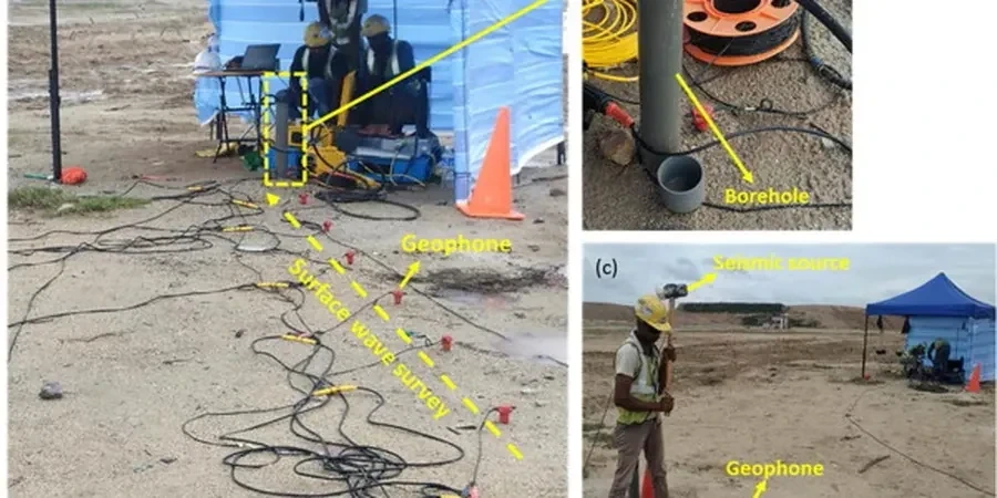
Method and coverage
Regional considerations
The Saanich basin is underlain by a succession of Quaternary deposits that include Vashon‑age glacial till, glaciomarine stony clay, and post‑glacial marine silts of the Capilano Sediments. These soft silts, encountered in pockets across the municipality, amplify ground motion in the 0.5–1.5 Hz range, which coincides with the natural frequency of mid‑rise structures. Without a microzonation study, a building designed for Site Class C may actually sit on Class D or E material, attracting 20–50 % higher spectral accelerations than assumed. The NBCC 2020 explicitly allows the use of site‑specific ground‑response analysis, and Saanich’s review engineers increasingly expect it for essential facilities, schools, and multi‑family wood‑frame buildings over three storeys. A missed soft‑soil lens can delay occupancy by months if the structural design must be revisited after foundation excavation.
Standards that apply
NBCC 2020 Division B, Section 4.1.8, ASTM D7400 Standard Test Methods for Downhole Seismic Testing, NCEER/Youd–Idriss 2001 liquefaction evaluation procedure, Eurocode 8 (EN 1998-1:2004) where referenced by client, ASCE 7-22 Chapter 21 site‑specific ground motion procedures
Complementary services
Site‑specific ground response analysis
One‑dimensional equivalent‑linear or non‑linear analysis using DEEPSOIL or Strata, with modulus reduction and damping curves calibrated to local Saanich silts and tills. Output includes surface acceleration time histories, response spectra, and amplification factors for the project’s design period.
Microzonation mapping for subdivisions and campuses
Multi‑point geophysical campaigns (MASW, HVSR, refraction) integrated with borehole and CPT data to produce GIS‑ready maps of Vs30, T0, and site class. Suitable for subdivision rezoning applications, school‑board campuses, and hospital expansions where building placement affects seismic cost.
Typical parameters
Quick answers
When does the District of Saanich require a seismic microzonation study instead of a default site class?
The district’s building review group typically requests a site‑specific study for post‑disaster buildings, essential facilities, assembly occupancies over 300 people, and any structure where the designer proposes a site class better than the default D/E presumed for the area. The request is driven by NBCC 2020 commentary J and the geotechnical reviewer’s judgment.
How long does a microzonation campaign take for a typical 2‑acre lot in Saanich?
Field work usually spans two to three days for MASW lines, a refraction profile, and possibly one calibration borehole. The analysis and reporting phase takes an additional 10–12 working days, assuming dry weather and reasonable site access.
What does a seismic microzonation study cost in Saanich?
Budget between CA$5.980 and CA$20.840, depending on the number of measurement points, the need for a calibration borehole, and the complexity of the ground‑response modelling. A small bare‑land site with two MASW arrays sits at the lower end; a campus‑scale map with boreholes and CPT soundings moves toward the upper bound.
Can the microzonation results be used directly by the structural engineer for the dynamic analysis?
Yes. We deliver the surface‑level acceleration response spectrum and, where requested, a suite of spectrum‑compatible time histories. The report includes the site period, the amplification factor, and the design spectral ordinates formatted to match the input requirements of structural software such as ETABS or SAP2000.